
Homebuyers · NRIs · Long-term buyers
Pay for address Local evidence, shown honestly
Your neighbourhood guide
Neighbourhood · Navi Mumbai · IN
7/7 evidence signals establishedA field note for curious people
Nerul
Mature premium Navi Mumbai node: strong schools, rail, and daily convenience
Built-out CIDCO node with education and Harbour-line strength, but recurring water cuts, weak power reliability, and poor footpaths. Prices around Rs 28,000/sq ft are premium versus Kharghar, while gross yields of roughly 3% are thin. Fits end-user families, students, and long-hold buyers, not yield-chasers.
Your neighbourhood guide is ready.
Price vs. quality of life
Is Nerul worth the price?
Prices near Rs 28,000/sq ft reflect a mature node with real schools, hospitals, and rail, but civic reliability still trails the premium.
Buying price (per sq ft)Rs 22,900-30,000 / sq ft (sector avg)
Typical monthly rentRs 35k-75k / mo (2BHK)
Yearly rental return~3% gross, ~2.3%-2.6% net
New construction & supplyBuilt-out node (mostly redevelopment and infill towers)
Find your fit
What is Nerul actually good for?
Get to know daily life
Everyday essentials
01
mixedCivic & utilities
Morbe piped water but scheduled cuts, weak power, and recurring drainage repairs
02
strong15-minute daily life
Dense everyday convenience: many schools, clinics, temples, and parks within 2 km
Education & learning13 within 2km · nearest 0m
Google Places scan verified 13 education & learning venues within 2km.
Local markets & shopping16 within 2km · nearest 0m
Google Places scan verified 16 local markets & shopping venues within 2km.
Everyday POIs16 shopping, 16 healthcare in 2 km
Hard POI counts show 16 shopping and 16 healthcare points within 2 km, with a nearest ATM 41 m away.[32]
03
mixedCommute & connectivity
Harbour and Uran rail is the backbone, but no metro reaches Nerul
Rail accessHarbour line, 3-5 min peak
Nerul station sits on the Harbour and Trans-Harbour lines with 3 to 5 minute peak frequency.[2]
Metro gapNo station at Nerul
Navi Mumbai Metro Line 1 runs only Belapur to Pendhar, so Nerul has no metro station.[2]
Road congestionSion-Panvel and Palm Beach choke
Concretisation and events at DY Patil Stadium repeatedly jam Juinagar and Nerul roads.[35]
04
mixedNew projects & what is changing
Redevelopment towers plus road and flyover works under construction
05
mixedBuying price & rent value
Premium pricing for a mature node, with thin yields and high society costs
Buying ratesRs 22,963-30,000 / sq ft
Sector 17 sits near Rs 22,963/sq ft while Palm Beach band crosses Rs 30,000/sq ft.[2][4]
Rents vs yieldRs 35k-75k, ~3% gross
2BHK rents of Rs 35,000 to 75,000 per month imply roughly 3% gross and 2.3% to 2.6% net yield.[2][20][22]
Appreciation8.5% YoY, 38% in 5 yrs
Capital appreciation runs about 8.5% YoY, 22.5% over three years, and 38% over five years.[2]
Through the year
A typical year around Nerul
Monthly averages from 2023–2025 show how air quality and weather change with the seasons.
Monthly mean US AQI
US AQIRegional model · approximately 45 km grid
Nov: 135 US AQI3 of 3 baseline years
Air temperature
°CRegional model · approximately 11 km grid
Nov: 26.6 °C3 of 3 baseline years
Monthly rainfall
mm/monthRegional model · approximately 25 km grid
Nov: 7 mm/month3 of 3 baseline years
Relative humidity
%Regional model · approximately 11 km grid
Nov: 66 %3 of 3 baseline years
Monthly averages smooth out individual high-pollution days. Regional model data from Open-Meteo. Sources & methodology
| Month | Monthly mean US AQI | Air temperature (°C) | Monthly rainfall (mm/month) | Relative humidity (%) |
|---|---|---|---|---|
| Jan | 1483/3 years | 24.43/3 years | 03/3 years | 633/3 years |
| Feb | 1313/3 years | 26.13/3 years | 03/3 years | 563/3 years |
| Mar | 1343/3 years | 27.43/3 years | 23/3 years | 603/3 years |
| Apr | 1243/3 years | 29.43/3 years | 13/3 years | 663/3 years |
| May | 1033/3 years | 29.73/3 years | 703/3 years | 743/3 years |
| Jun | 733/3 years | 28.23/3 years | 4053/3 years | 833/3 years |
| Jul | 653/3 years | 26.33/3 years | 7923/3 years | 903/3 years |
| Aug | 693/3 years | 26.43/3 years | 3693/3 years | 883/3 years |
| Sep | 773/3 years | 26.33/3 years | 4153/3 years | 883/3 years |
| Oct | 1143/3 years | 27.83/3 years | 763/3 years | 783/3 years |
| Nov | 1353/3 years | 26.63/3 years | 73/3 years | 663/3 years |
| Dec | 1233/3 years | 25.33/3 years | 03/3 years | 613/3 years |
Satellite X-Ray · Measured from orbit
What Nerul looks like from space
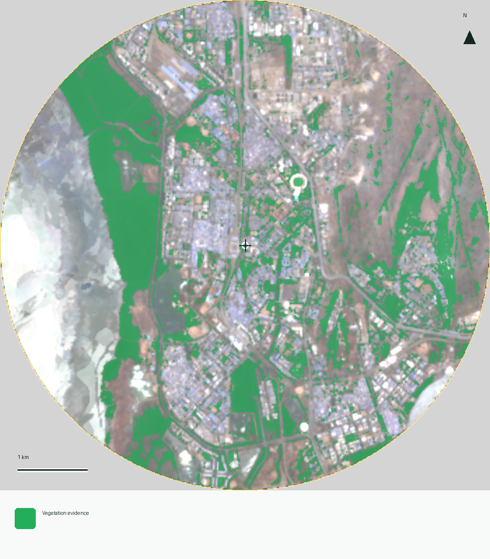
3.5 km radius · Jan – Mar 2025 – Apr – Jun 2026 · Deterministic physical measurements (no AI guesswork)
Heat & shade from space-2.6°C anomaly
Cool island (2.6°C cooler than surroundings)
Tree canopy, water, or open ground keeps surface temperatures 2.6°C cooler than the surrounding belt.
Concrete vs. tree canopy41.5% built · 20.8% green
Mixed urban density (41.5% built-up · 20.8% green cover)
Balances 41.5% built structures and streets with 20.8% visible tree and park cover.
Topography & rainwater flow26m elev · 53/100 bowl
Moderate terrain slope (53/100 runoff convergence)
Sits at ~26m elevation with typical urban slope; monsoon drainage depends on street-level storm lines.
Spatial catchment radar · 2km radius
Nerul on the ground
Nerul is located in Navi Mumbai, IN.
Right now
Live contextUnavailable
NerulNeighbourhood · Navi Mumbai · INMap available when in view
Quality signals · Expected-value index
What the evidence establishes (0–100%)
7 of 7 signals have a cited estimate combining 2km map data and researched fundamentals. Blank scores need more evidence.Nearby & same-budget comparison
Compare Nerul with nearby & similar-price areas
Inspect the fundamental grids of neighbouring areas and similar-budget pockets side by side to compare buying prices, rental returns, and daily amenities.
Behind this guide
Sources & things to check
40 research sources · air & weather dataOpen
Behind this guide
Sources & things to check
- 01niua.in · niua.in · accessed 3 Nov 2026
- 02revaahomes.com · revaahomes.com · accessed 3 Nov 2026
- 03mumbailive.com · mumbailive.com · accessed 3 Nov 2026
- 0499acres.com · 99acres.com · accessed 3 Nov 2026
- 05lokmattimes.com · lokmattimes.com · accessed 3 Nov 2026
- 06revaahomes.com · revaahomes.com · accessed 3 Nov 2026
- 07maharashtratimes.com · maharashtratimes.com · accessed 3 Nov 2026
- 08homesbuildings.com · homesbuildings.com · accessed 3 Nov 2026
- 09timesofindia.indiatimes.com · timesofindia.indiatimes.com · accessed 3 Nov 2026
- 10realty.economictimes.indiatimes.com · realty.economictimes.indiatimes.com · accessed 3 Nov 2026
- 11urbanacres.in · urbanacres.in · accessed 3 Nov 2026
- 1299acres.com · 99acres.com · accessed 3 Nov 2026
- 13freepressjournal.in · freepressjournal.in · accessed 3 Nov 2026
- 14ghar.tv · ghar.tv · accessed 3 Nov 2026
- 15mumbailive.com · mumbailive.com · accessed 3 Nov 2026
- 16realestateindia.com · realestateindia.com · accessed 3 Nov 2026
- 17hindustantimes.com · hindustantimes.com · accessed 3 Nov 2026
- 1899acres.com · 99acres.com · accessed 3 Nov 2026
- 19mumbailive.com · mumbailive.com · accessed 3 Nov 2026
- 20nobroker.in · nobroker.in · accessed 3 Nov 2026
- 21timesofindia.indiatimes.com · timesofindia.indiatimes.com · accessed 3 Nov 2026
- 22squareyards.com · squareyards.com · accessed 3 Nov 2026
- 23particle.news · particle.news · accessed 3 Nov 2026
- 24squareyards.com · squareyards.com · accessed 3 Nov 2026
- 25indianexpress.com · indianexpress.com · accessed 3 Nov 2026
- 26pocketghar.com · pocketghar.com · accessed 3 Nov 2026
- 27lokmattimes.com · lokmattimes.com · accessed 3 Nov 2026
- 28ilovenavimumbai.com · ilovenavimumbai.com · accessed 3 Nov 2026
- 29remumbai.in · remumbai.in · accessed 3 Nov 2026
- 30remumbai.in · remumbai.in · accessed 3 Nov 2026
- 31ndtvprofit.com · ndtvprofit.com · accessed 3 Nov 2026
- 32squareyards.com · squareyards.com · accessed 3 Nov 2026
- 33mumbailive.com · mumbailive.com · accessed 3 Nov 2026
- 34holidify.com · holidify.com · accessed 3 Nov 2026
- 35mirrornow.in · mirrornow.in · accessed 3 Nov 2026
- 36google.com · google.com · accessed 3 Nov 2026
- 37constructionworld.in · constructionworld.in · accessed 3 Nov 2026
- 38tripadvisor.de · tripadvisor.de · accessed 3 Nov 2026
- 39tendershark.com · tendershark.com · accessed 3 Nov 2026
- 40holidify.com · holidify.com · accessed 3 Nov 2026
Air & weather: sources and methodology
Monthly averages cover 2023–2025. Each year’s monthly value is calculated first, then qualifying years receive equal weight. AQI, temperature and humidity require 90% observation coverage; rainfall requires complete daily totals. At least two years support every displayed month. Gaps show insufficient coverage.
Air quality uses mean US AQI. Temperature is air temperature at 2 metres; humidity is relative humidity at 2 metres. Rainfall is the average of each year’s monthly rainfall total. Observations use Asia/Kolkata. Collected 2026-10-20.
- Monthly mean US AQI
CAMS global archived atmospheric composition forecasts · approximately 45 km grid. Open-Meteo (CC BY 4.0); Copernicus Atmosphere Monitoring Service.
Modelled · experimental. Grid centre 19.00, 73.00.
- Air temperature
ERA5-Land historical weather · approximately 11 km grid. Open-Meteo (CC BY 4.0); Copernicus Climate Change Service / ERA5-Land.
Modelled · experimental. Grid centre 19.00, 73.00.
- Monthly rainfall
ERA5 historical rainfall · approximately 25 km grid. Open-Meteo (CC BY 4.0); Copernicus Climate Change Service / ERA5.
Modelled · experimental. Grid centre 19.00, 73.00.
- Relative humidity
ERA5-Land historical weather · approximately 11 km grid. Open-Meteo (CC BY 4.0); Copernicus Climate Change Service / ERA5-Land.
Modelled · experimental. Grid centre 19.00, 73.00.
These regional patterns provide seasonal context. Monthly means smooth out individual high-pollution days.
Local voices
What the web cannot know on its own.
Personal experience stays separate from sourced research and only becomes a public pattern after the privacy threshold.Know it firsthand?
Tell us what daily life actually feels like.
Ten structured questions create a personal portrait before community patterns enter the room.Community local read
Patterns appear after enough eligible local voices.
Your contribution can be saved now. Counts and percentages stay hidden until the privacy threshold is met.Field notes Beta
What's happening on the ground.
0 notes · 0 activeLoading field notes…
Start with your local read
Measurements work best when we know how you know the place.
Complete the neighborhood read, then take a focused four-signal mission.Satellite analysis · published
The physical story of Nerul.
Satellite evidence showed vegetation across 20.8% of the usable area inside the analysis circle. Developed or hard-surface land was mapped across 41.5% of the usable area. Both water-detection methods agreed across 16.0% of the usable area. The wider one-method water evidence covered 18.4%.
Green cover20.8%
Built-up area41.5%
Surface temperature40.6°C
Air quality53 (India CPCB)